Hiking
Slot canyons, an alcove the size of a cathedral, and the second-largest gathering of arches in the country — most of it without a queue.
Fruita sits between two very different kinds of desert. North of the river, red rock canyons cut down through sandstone and almost nobody is out there. South, the Colorado National Monument stands up in towers you can see from the highway.
The big ones
Plan the whole day
These are the hikes people drive across the state for. All of them need water, an early start, and a look at the weather first.
Rattlesnake Arches
5 mi round tripModerate – hard
The second-largest concentration of natural arches in the United States, after Arches National Park. The upper road opens April 15 to August 14 and the lower road August 15 to February 14, with motorised travel closed February 15 to April 15. High clearance is mandatory, four-wheel drive strongly advised, and the last two miles are rough. Impassable when wet. Day use only.
Rattlesnake Arches via Pollock Bench
15 mi round tripHard
The long way in, on foot, when the road is closed or you would rather earn it. A full day — start before sunrise and carry more water than you think.
Mee Canyon
Varies · primitive routeHard
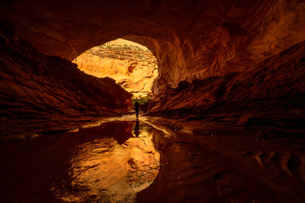
The alcove in the photograph above. The trail is marked only by cairns and drops steeply through sandstone layers with exposed cliff edges. Route-finding required. No camping at the alcove.
Devils Canyon Loop
6–7 mi loopModerate
Red rock washes, cottonwoods and canyon walls, fifteen minutes from downtown. No entrance fee, and the trailhead parking is right off Highway 340.
Pollock Bench Loop
About 7 miModerate
The bench above Devils Canyon, with long views and far fewer people than the canyon floor.
Out here the trail is a line of rock cairns and your own judgement. That is the appeal, and it is also the warning.
Mee Canyon · McInnis Canyons NCA
Short and worth it
Under two hours
Inside Colorado National Monument. Entry is $25 per vehicle for seven days, $20 by motorcycle, $15 on foot or bike, or $45 for a monument annual pass.
Otto’s Trail
0.75 mi · 85 ftEasy
The best view for the least effort anywhere near town. Independence Monument and the Coke Ovens, straight off the rim.
Window Rock
0.35 mi · 60 ftEasy
Ten minutes from the car to a hole in the cliff and the whole of Monument Canyon underneath it.
Coke Ovens
1 mi · 180 ftEasy
Down to an overlook of the rounded domes that give the formation its name.
Canyon Rim
1 mi · 100 ftEasy
Flat, along the edge, and the right choice at sunset.
Devils Kitchen
1.2 mi · 225 ftEasy – moderate
Ends in a room of upright boulders that feels built rather than eroded. Popular with kids; the last scramble needs hands.
Longer days in the Monument
Half day and up
Monument Canyon
7–12 mi · 850 ftModerate – hard
Drops off the rim and walks you to the base of Independence Monument, the tallest free-standing formation in the park. Can be done as a through-hike with a car at each end.
Serpents Trail
3.5 mi round tripModerate
The old road up the face, built in the early 1900s and once called the crookedest road in the world. Switchback after switchback, with Grand Junction opening up behind you.
No Thoroughfare Canyon
5.5 miEasy – moderate
Mostly gentle walking up the canyon bottom, with waterfalls in spring when there is water to spare.
Drive up to Otto’s Trail for the view, then come back down and walk into Devils Canyon. Twenty minutes of driving buys you the two things this landscape does best — standing on top of it, and standing inside it.
Before you go
There is no water on any of these trails. Carry more than you plan to drink, and in summer be off the exposed sections before midday — the canyons hold heat long after the sun moves.
McInnis Canyons roads turn to clay when wet and stay impassable for a day or two afterwards. Check the forecast, and do not count on cell service once you drop into a canyon.
McInnis Canyons
Almost everything on this page happens inside one protected landscape that starts at the edge of town — and most people driving I‑70 have never heard of it.
McInnis Canyons National Conservation Area was designated by Congress on 24 October 2000, and the Black Ridge Canyons Wilderness sits inside it — the piece that holds Rattlesnake Arches, the second-largest concentration of natural arches in North America.
It is also full of things that are not scenery. There are petroglyphs and pictographs on these walls, fossils of international importance in the rock, and a section of the historic Old Spanish Trail running through. The Kokopelli Trail starts here and runs 142 miles to Moab.
- Leave fossils and artefacts exactly where you find them.
- Never touch rock art — oil from hands breaks it down. View it with binoculars.
- Rattlesnake and Mee Canyons are day use only. No camping at the Mee alcove.
- Overnight trips on the Ruby–Horsethief river section need a permit, year round, booked on recreation.gov.
Worth the drive in daylight. Worth a great deal more at the end of it.
Rattlesnake Arches · Black Ridge Canyons Wilderness
Stay the night, hike at first light
The best hours out here are the two after sunrise. That is much easier if you woke up in Fruita.